Appendix B. CITY OF PORT ST. LUCIE LAND USE CONVERSION MANUAL
I. INTRODUCTION
This section briefly summarizes background factors underlying the land use conversion concept and identifies the purpose and intent of the land use conversion manual.
In 1982-83, the City of Port St. Lucie Comprehensive Plan Evaluation and Appraisal Report identified several land use issues requiring changes in the City's land use plan and related policies. Issues identified included:
• Platted small single-family lots along major roadways have deterred development;
• Need for more diverse housing structure types within the community;
• Shortage of land available for both commercial and institutional facilities; and
• Traffic flow has been inhibited along major thoroughfares by excessive curb-cuts serving single-family homes on 80-foot lots
In response to these issues, the City prepared and adopted land use conversion policies to promote: 1) Assembly of small single-family lots along major thoroughfares; and 2) Development of multiple-family residential housing as well as additional commercial and institutional activities on these strategically located sites along major transportation corridors.
This manual is intended to explain the land use conversion process, available conversion options, and implementation policies. The manual addresses requirements for land assembly, rezoning requirements, and related site plan and design considerations. The manual is intended to facilitate administrative requirements for implementing the Comprehensive Plan land use conversion policies.
The land use conversion process is designed to accomplish the following objectives:
• Promote assembly of single-family residential lots along strategically located segments of major thoroughfares;
• Encourage well-designed non-residential development and multiple family housing with controlled access along major thoroughfares:
• Improve traffic circulation by restricting curb-cuts and providing effective systems for off-street parking and internal circulation;
• Alleviate potential adverse impacts on single-family development by mandating standards for building setbacks, landscaping, screening, and buffering; and
• Foster unified design in land use conversion projects by requiring unity of title and application of good principles of site design.
II. LAND USE CONVERSION AREAS AND APPLICABLE REGULATIONS
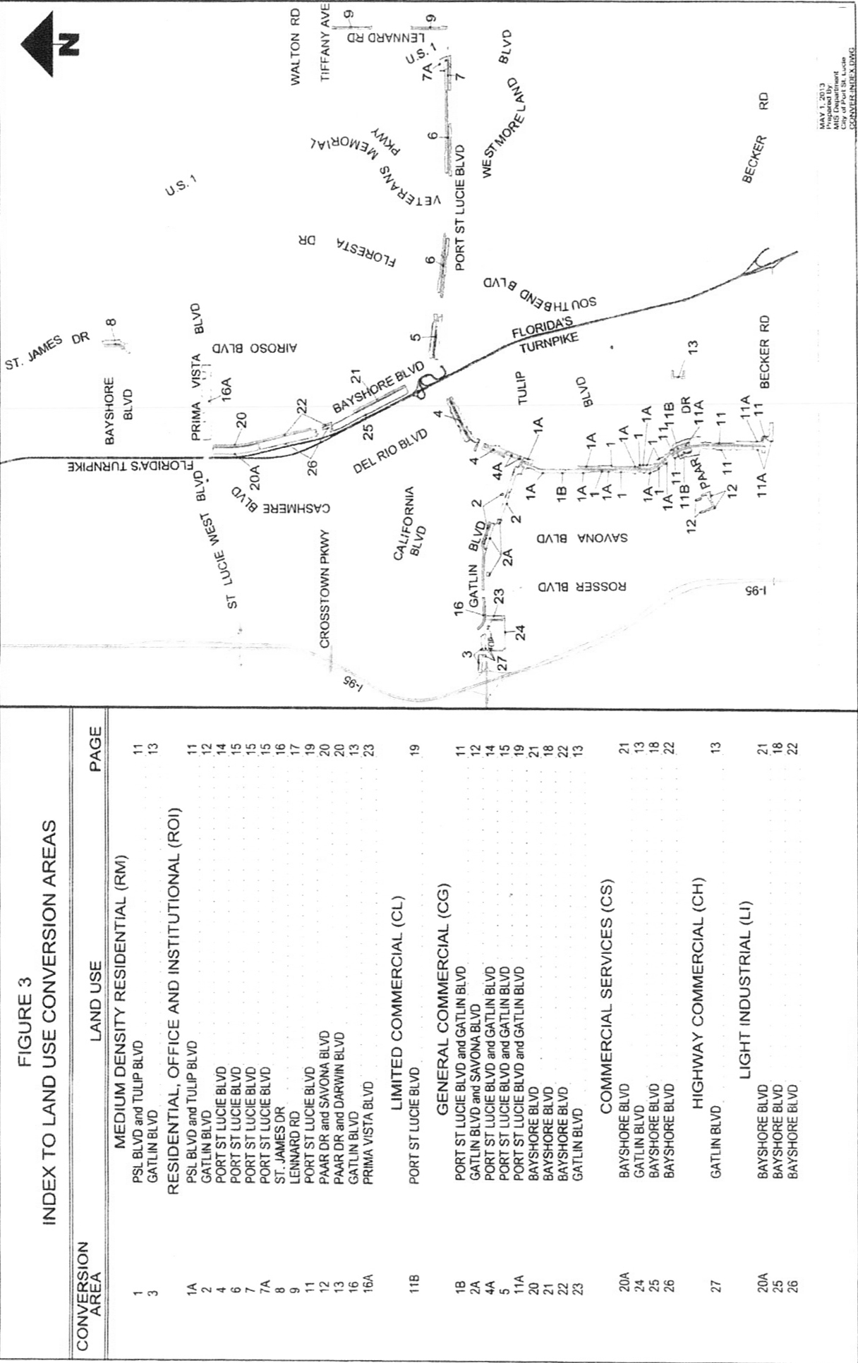
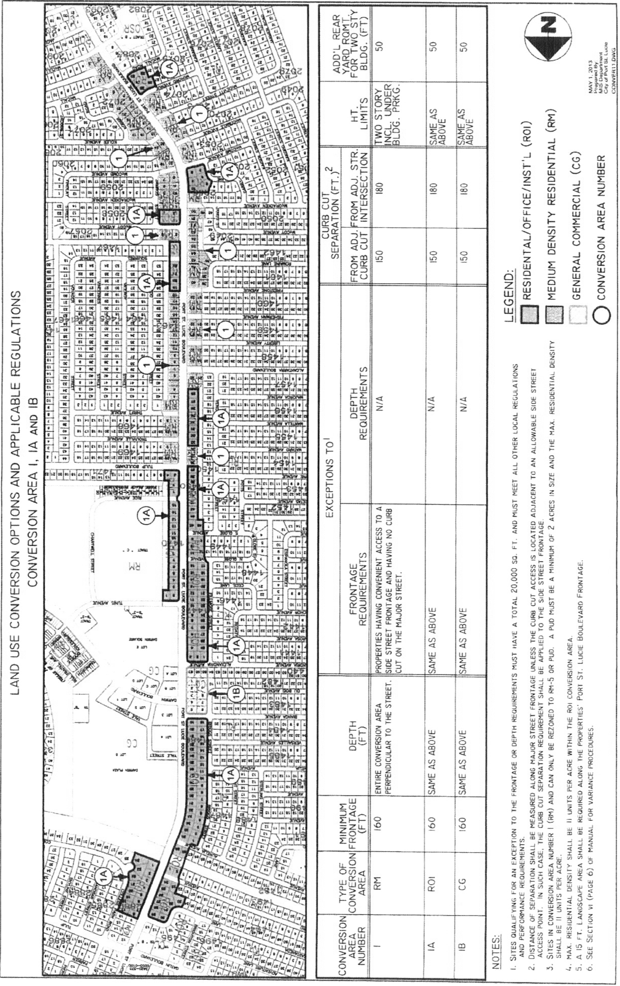
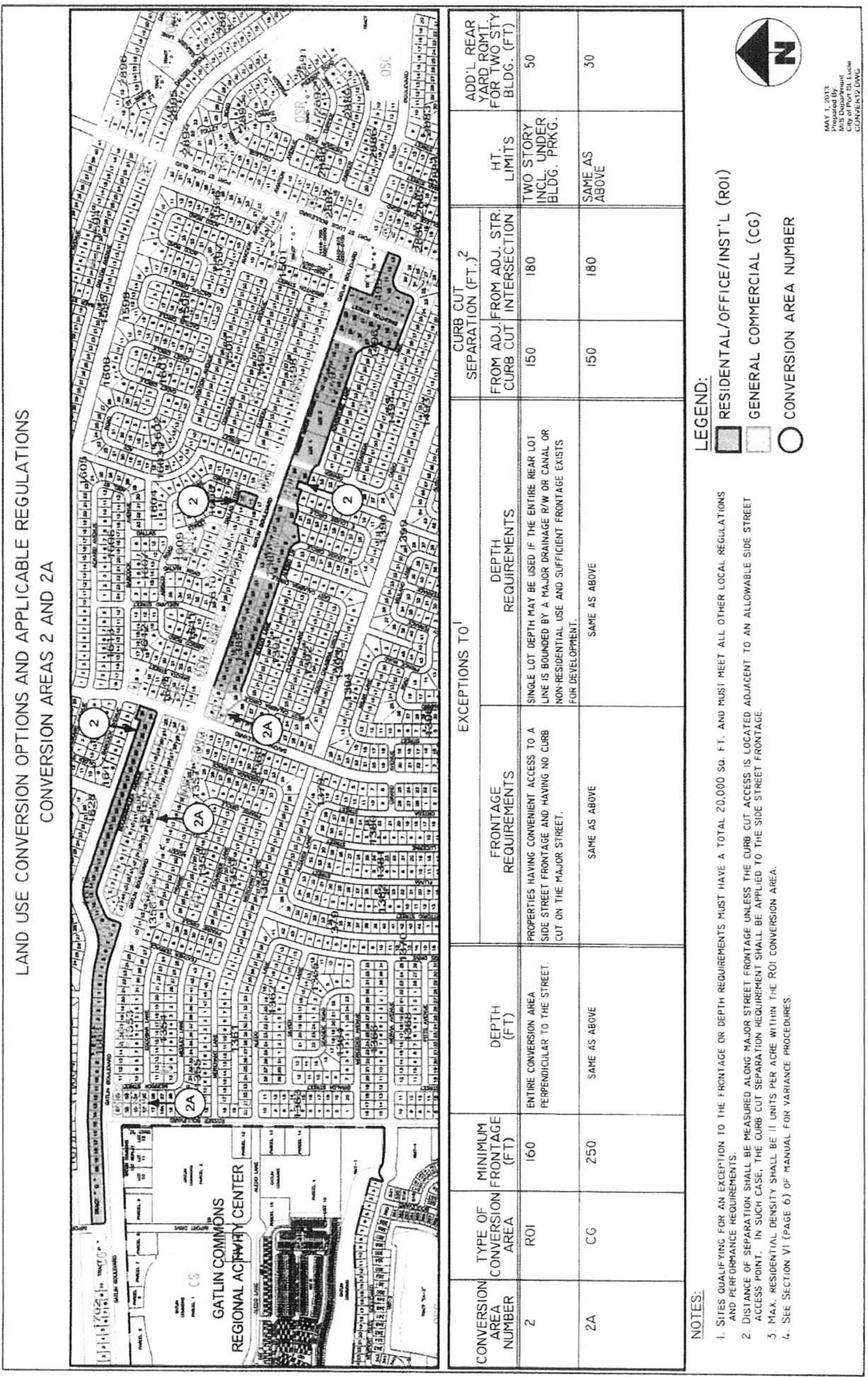
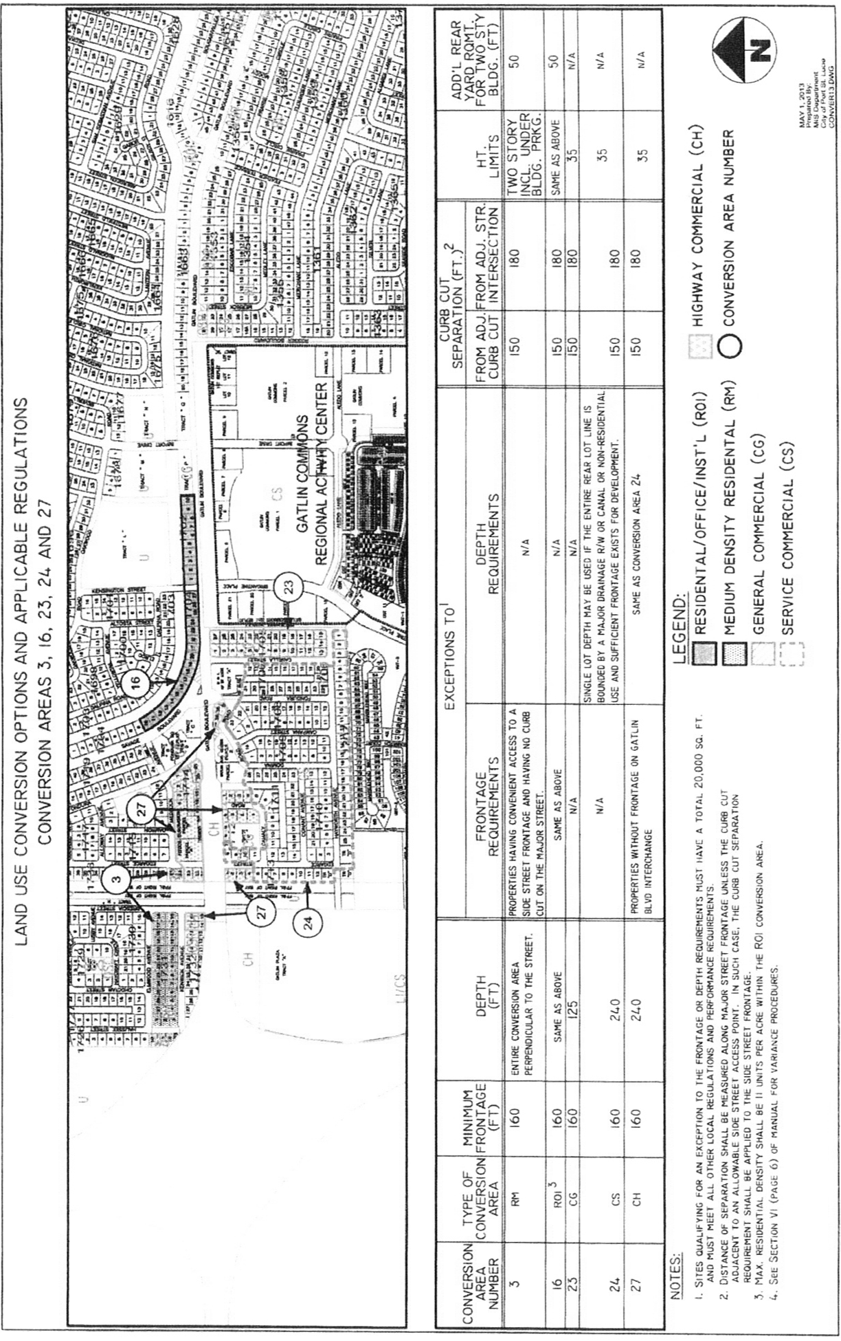
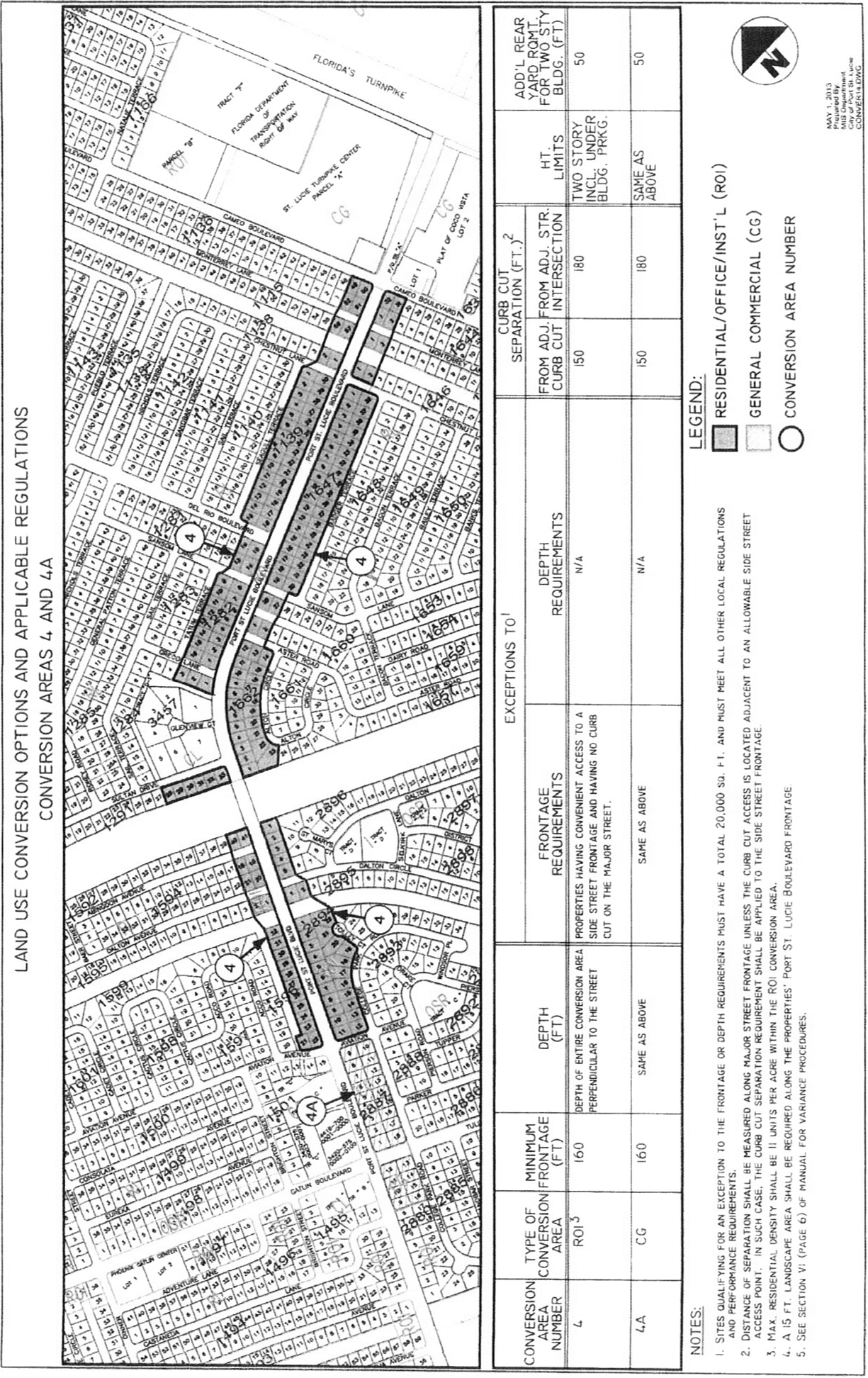
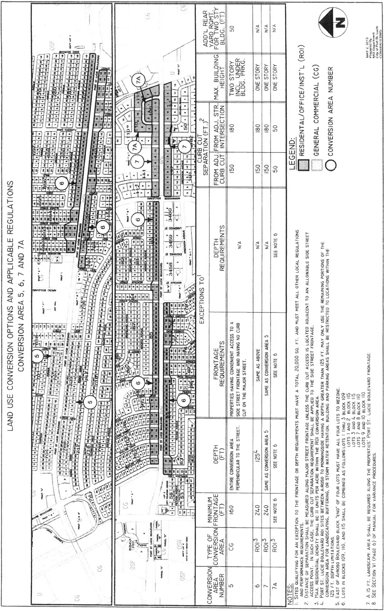
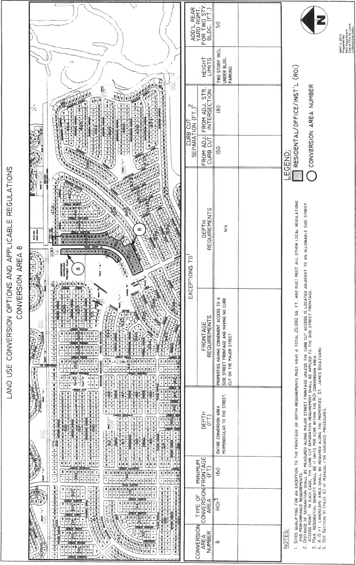
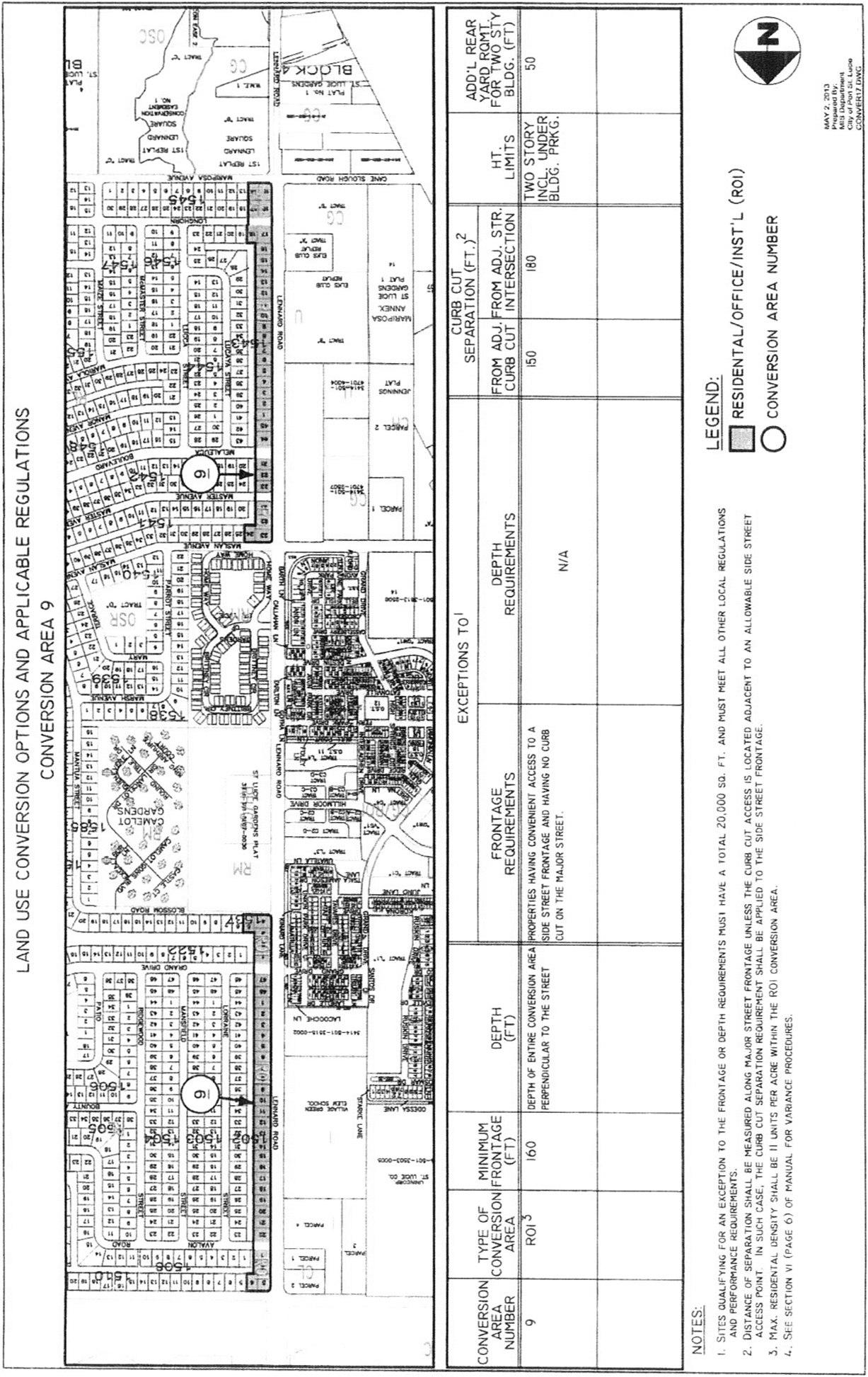
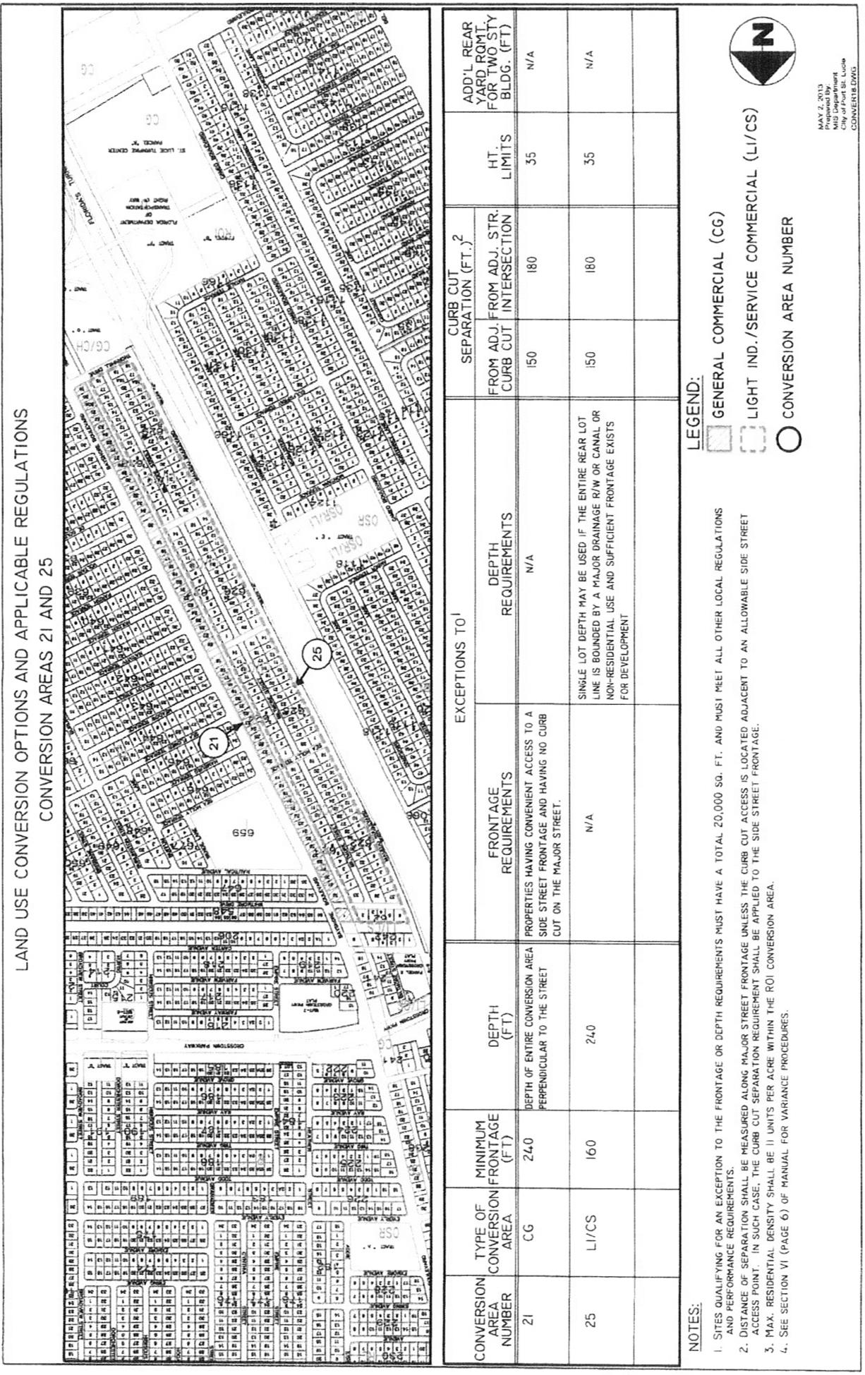
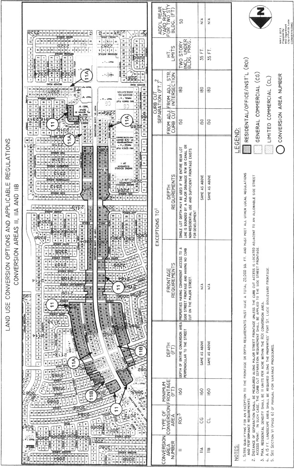
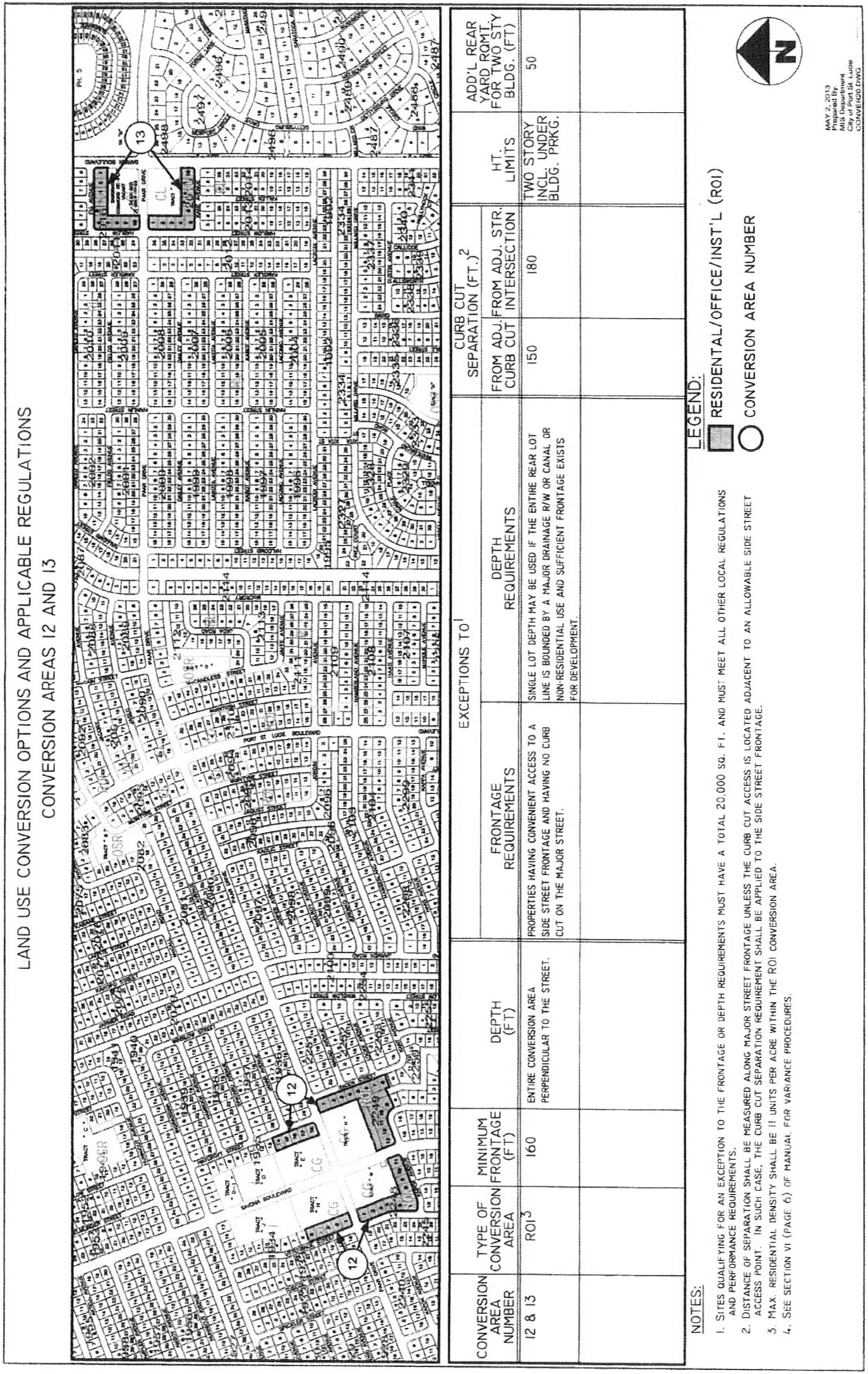
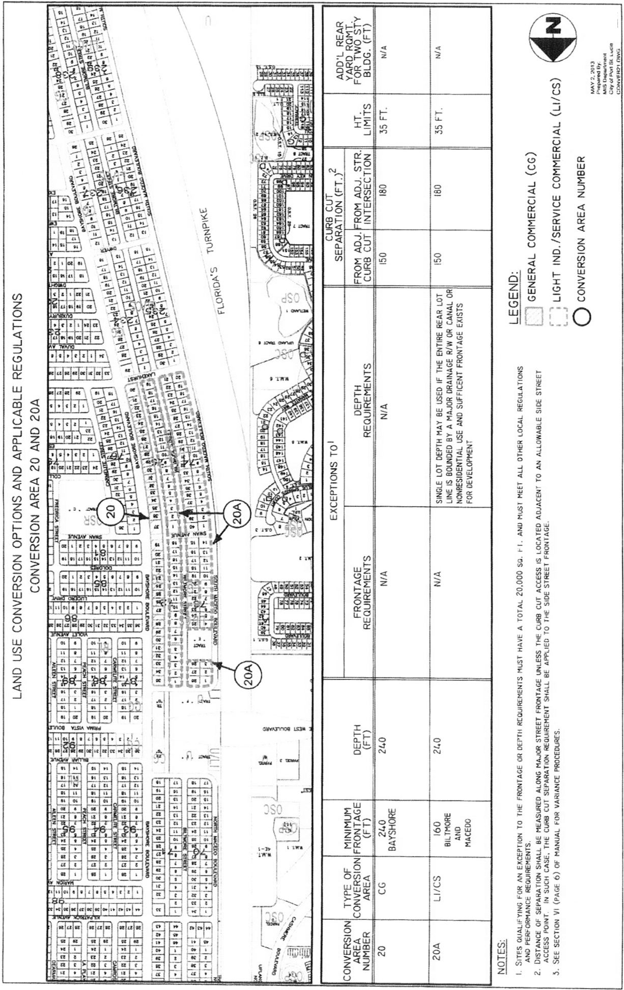
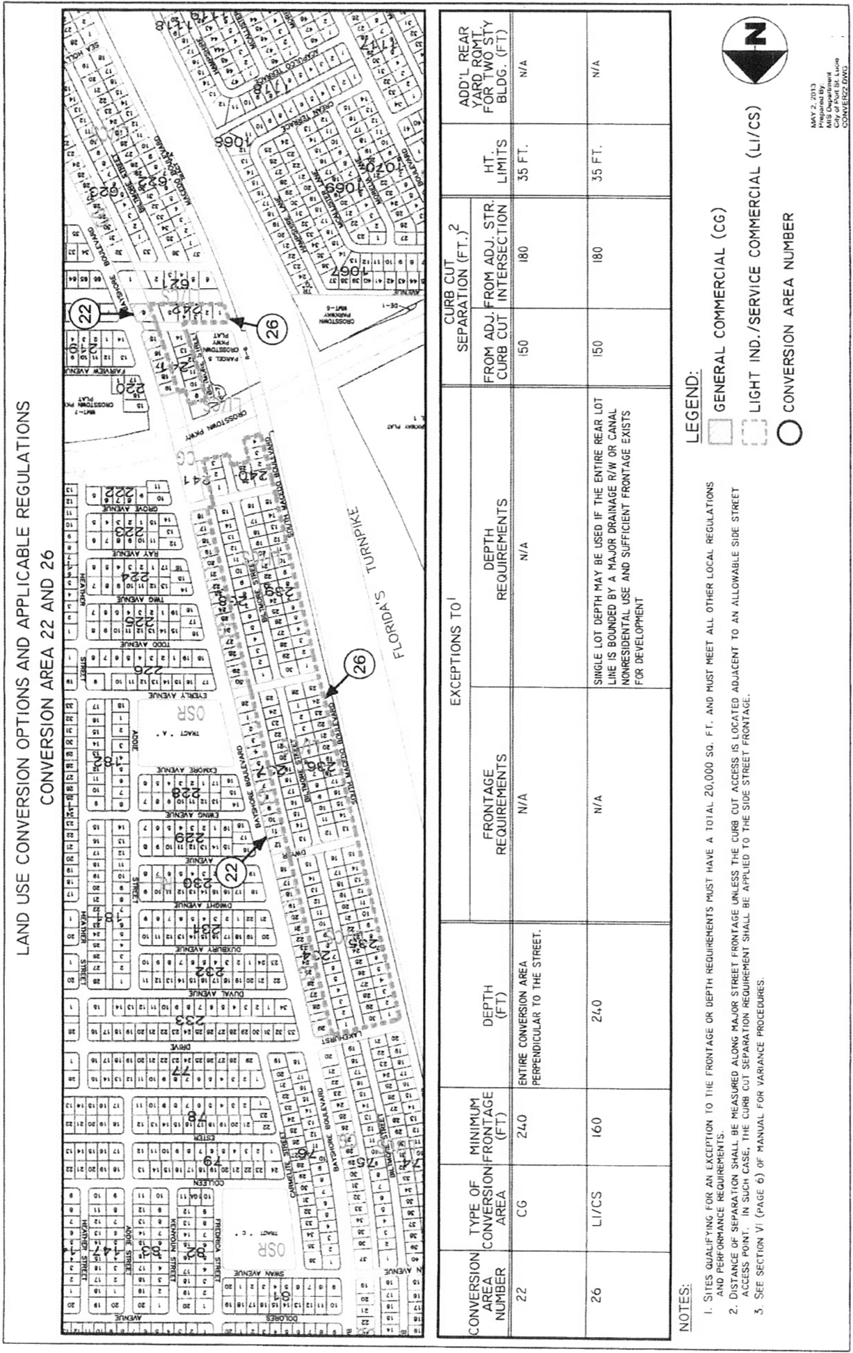
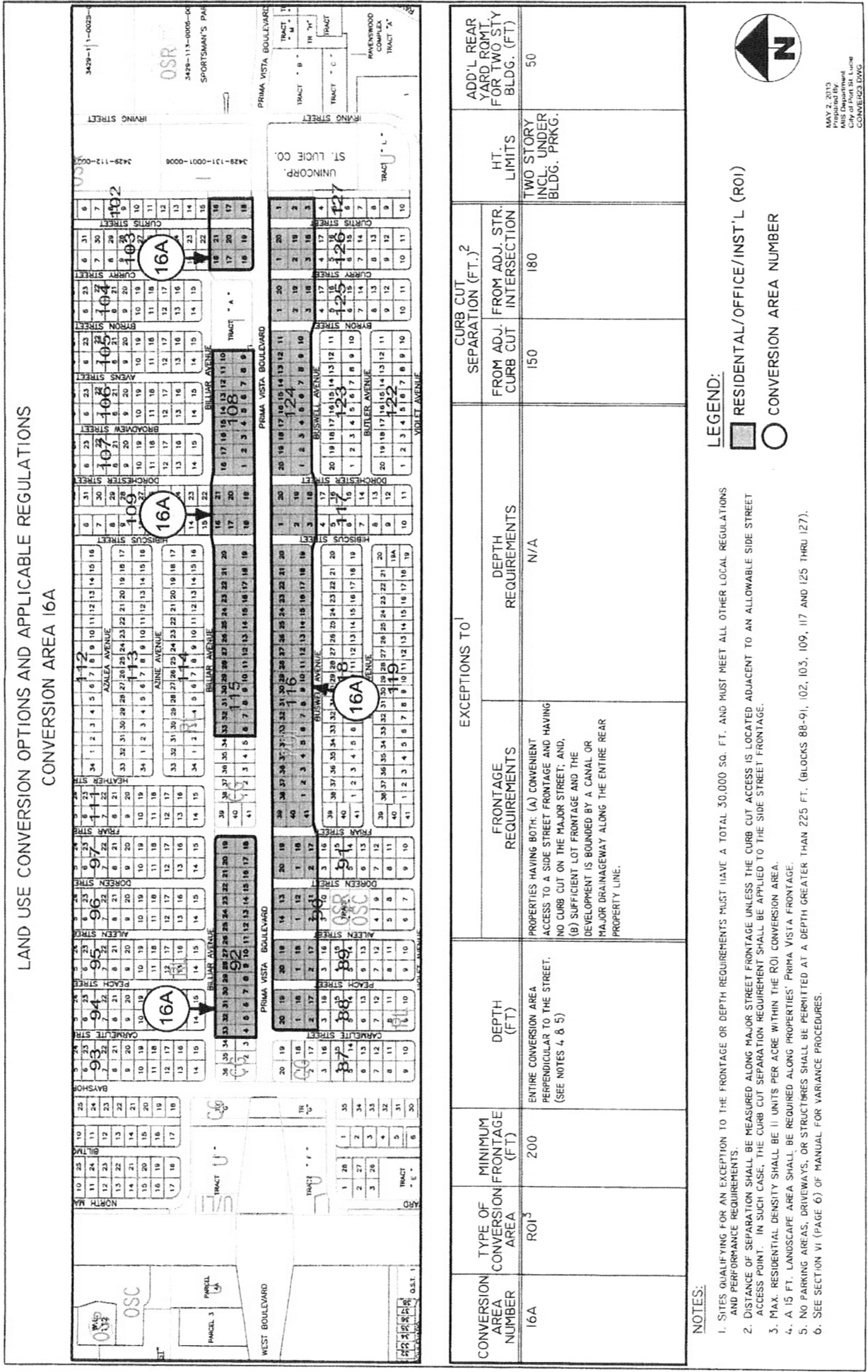
This section identifies the various types of land use conversion areas within the City of Port St. Lucie. Figure 3 delineates the general location of the conversion areas presented in the City of Port St. Lucie Comprehensive Plan. Pages 11 through 23 identify the individual conversion areas on small area maps. These maps specify the frontage and depth requirements, minimum lot size, minimum curb-cut separation, maximum height, and rear yard requirements for each individual conversion area.
In addition, Table I (page 7) summarizes the zoning districts which are compatible for each type of land use conversion.
III. LAND ASSEMBLY REQUIREMENTS
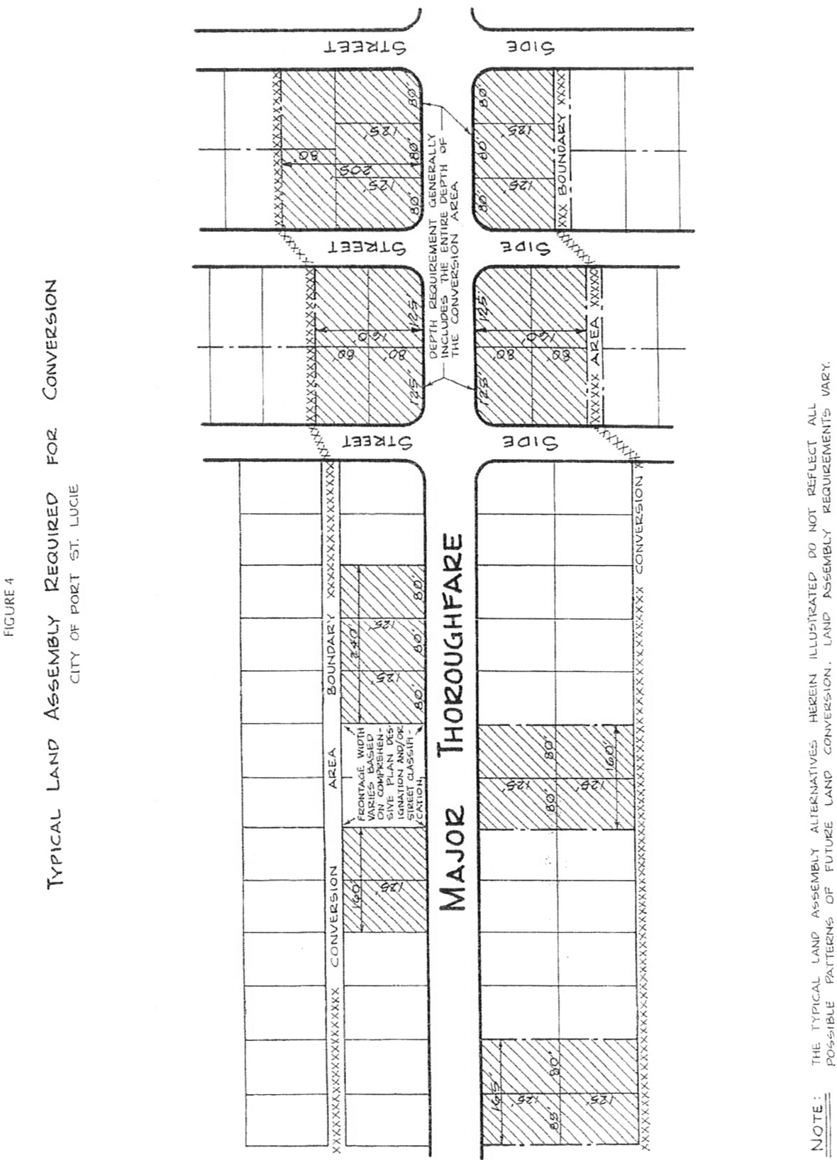
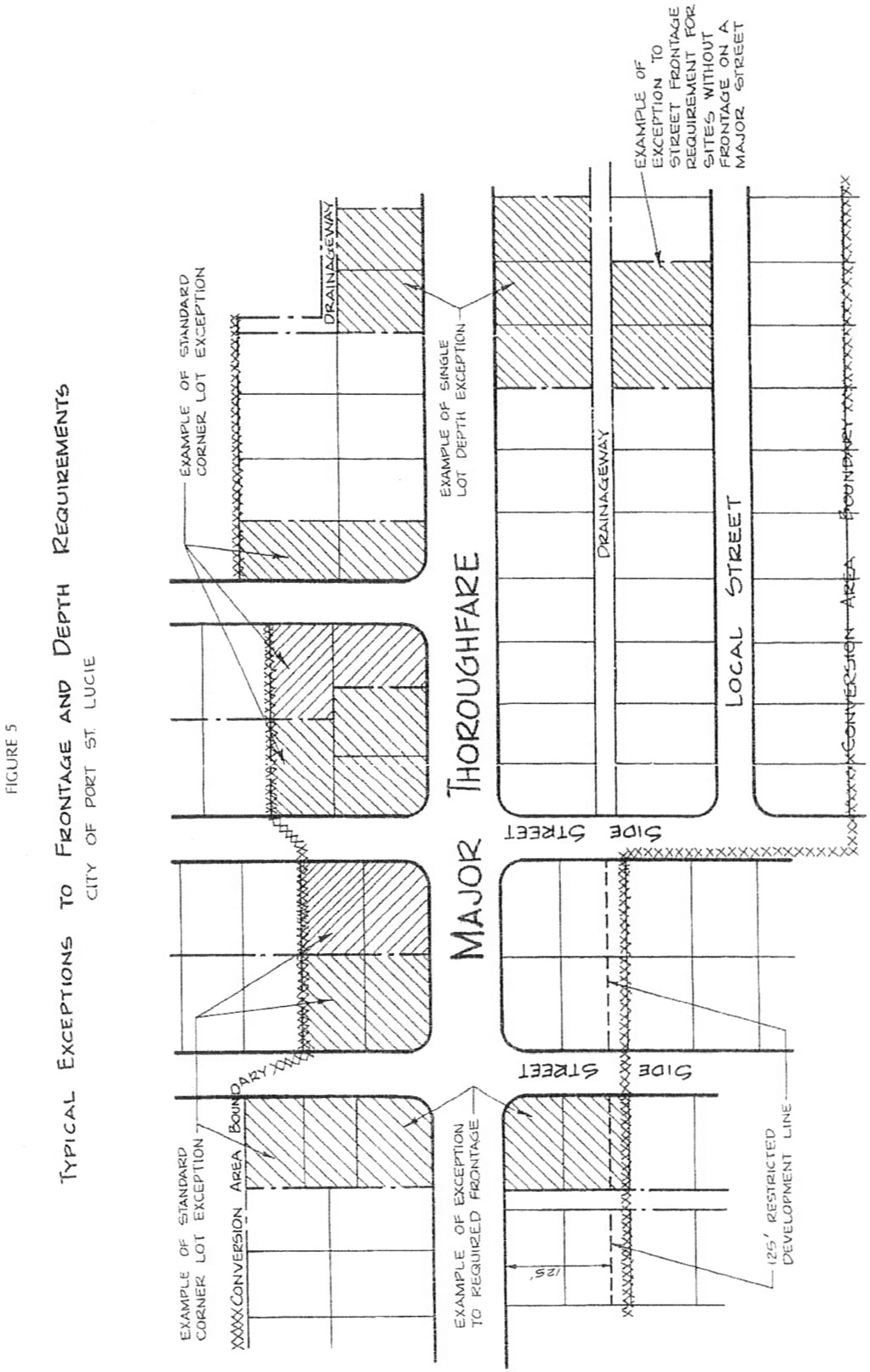
Required land assembly is primarily determined by major thoroughfare frontage and depth requirements as noted in the individual conversion area maps, and illustrated in Figure 4 (page 24). I he minimum required land area is 20,000 square feet. Exceptions to frontage and depth requirements are illustrated in Figure 5 (page 26).
Minimum Area Requirements/Frontage and Depth Requirements
The minimum area for a land use conversion site is 20,000 square feet, although several land use conversion areas require an area upwards to 60,000 square feet. Frontage and depth requirements and typical exceptions to the rule are graphically presented on Figures 4 and 5, respectively.
A major variation of the 20,000 square feet minimum area requirement applies to several sites with a depth greater than 125 feet which are located on Port St. Lucie Boulevard between Airoso Boulevard and Morningside Boulevard. On these sites the area extending beyond the 125 feet depth limitation can only be utilized for landscaping, buffering, retention and other such uses. The minimum site size is intended to apply to the total land area which is actually buildable, i.e., the area within the 125 feet buildable depth. The only exception occurs when a drainage right-of-way, tract, or a prior conversion precludes combining additional property.
Blocks 87-91. 102, 103, 109. 117 and 125-127, which are located within the Prima Vista Boulevard Conversion Area (map on page 23) prohibit parking areas, driveways, or structures at a depth greater than 225 feet. On these blocks the area extending beyond the 225 feet depth limitation can only be utilized for landscaping, buffering, retention and other such uses.
Avoiding Isolated Lots
Rezoning petitions for the conversion of residentially zoned lands should avoid the isolation of lots which are of insufficient size to meet the performance standards established for a particular conversion area. In cases where the petition results in the isolation of such lots, the City Council shall have the option of denying the petition or requiring the provision of joint driveways and parking lot easements in order to allow the isolated lots to be integrated with adjacent conversion areas which are consistent with the applicable performance standards.
Unified Ownership
At the time a rezoning application for land use conversion is submitted, applicants are required to submit appropriate legal documentation demonstrating conformity with unified ownership of the properties involved. The Legal Department will prepare a unity of title and will record the unity of title after the rezoning is approved by the City Council.
IV. REZONING PROCESS
When the land assembly requirements of the land use conversion process are met, the applicant must apply for a zoning map amendment. Sections 158.315 through 158.322 inclusive of the Zoning Code describe the zoning process, including detailed stipulations governing procedures and timing considerations. Major factors included in the rezoning procedures are identified below.
Rezoning Application and Filing Fee
An application for amending the zoning map should be obtained from the Zoning Administrator. The application for amendment must: 1) Be signed by the applicant; 2) include the applicant's name and address; and 3) be verified under oath by the applicant pursuant to Section 158.316 of the Zoning Code.
All applications for amending the Zoning Code must be submitted to the Zoning Administrator accompanied by a filing fee. The filing fee will be as established by the City Council to cover the expenses of handling the amendment application, providing public notice, taking an official record at public hearings, and for other purposes. No fee will be refunded except as expressly authorized by the City Council.
Review of the Rezoning Application
Rezoning applications are reviewed by the City Planner, who forwards comments and recommendations to the Planning and Zoning Board. The Planning and Zoning Board establishes a date for a public hearing and carries out notice requirements of Section 158.318 of the Zoning Code. The City Council considers the recommendations of the Planning and Zoning Board and convenes at least one public hearing prior to acting on the rezoning petition. Procedures for a City Council public hearing and notice requirements are established in Section 158.319 of the Zoning Code. Any interested person has the right to submit oral or written testimony at the subject public hearings. However, evidence which is immaterial, irrelevant, or unduly repetitious may be excluded from the official record on the application.
Criteria for Review and Timing of the Rezoning Process
The application for rezoning within land use conversion areas is evaluated based on its relationship to the Comprehensive Plan, or element or portion thereof. No application for land use conversion may be approved if it is found to be inconsistent with the adopted Comprehensive Plan.
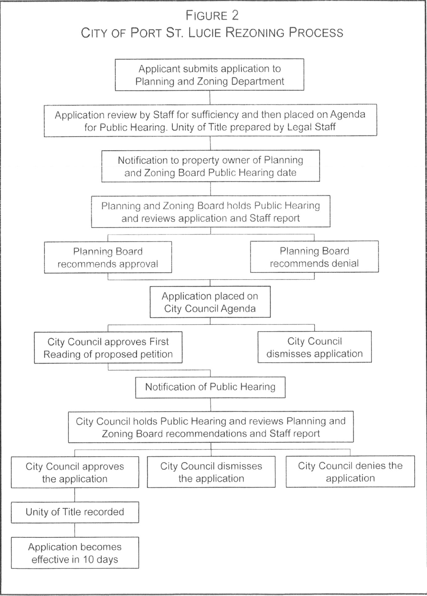
The rezoning process generally requires 60 to 90 days. However, the process can extend over a much longer duration in cases where divisive development issues arise. A flow chart of the rezoning process, including timing considerations, is presented in Figure 2 (page 10).
V. SITE PLAN AND DESIGN CONSIDERATIONS
Several site plan and design considerations are mandated as prerequisites for a land conversion project. This section identifies such requirements, including off-street parking; curb-cut limitations and joint access agreements; building height restrictions and rear yard setback provisions; landscaping, screening, and buffering; and unified ownership.
Off-Street Parking
Zoning for multiple-family residential development will not be approved within land use conversion areas unless compliance with off-street parking requirements and curb-cut restrictions are demonstrated. Such demonstration must include legal assurances for accommodating present and possible future needs for joint use of off-street parking access ways and curb-cuts in order to avoid undue proliferation of curb cuts on major thoroughfares. Section 158.221 of the Zoning Code stipulates detailed off-street parking provisions. Controlled curb-cuts and joint access agreements are discussed below.
Curb-Cuts
The minimum distance between curb-cuts providing access to land use conversion areas along major thoroughfares must be 150 feet and the minimum distance from a street intersection must be 180 feet. Curb-cuts must be restricted to locations abutting a major thoroughfare, as opposed to local residential streets, excepting allowable side street access points approved as part of the site plan review process.
The City Code of Ordinances includes a variance procedure through which an applicant may request a variance to stipulate curb-cut restrictions. However, no such variance can be granted unless variance criteria established in the Zoning Code are met. In addition, the following assumptions must be satisfied:
1)
All other performance standards are satisfied;
2)
Plans for vehicular, bicycle and pedestrian circulation indicate that projected traffic generation will not adversely impact traffic flow on or off the site;
3)
No other feasible traffic circulation plan is available to service the site;
4)
The density and/or intensity of development proposed for the site is determined not to exceed a reasonable threshold considering site limitations, traffic impacts, and the need to maintain safe and convenient access along major thoroughfares; and,
5)
The applicant has agreed to provide improvements or other equitable contributions which may be necessary to protect against adverse transportation Impacts.
Joint Access Agreements
Rezoning petitions for land use conversion which result in isolated lots incapable of meeting the off-street parking requirements and curb-cut restrictions shall be denied by the City Council or required to acquire agreements from adjacent developments for joint driveways and parking lot easements. All joint access parking agreements must be submitted as part of the rezoning application and must be approved by the City Attorney prior to approval of the petition. Preparation of joint access agreements must reflect specifications consistent with Section 158.222: Access Standards, within the City Zoning Code.
In addition, per the City of Port St. Lucie Citywide Design Standards pedestrian and vehicular connections shall be provided between adjacent parcels and buildings at the time of site plan approval. Cross-access agreements shall be obtained by adjacent property owners.
Special Height and Yard Requirements
The maximum height of any structure developed with a "Medium Density Residential" (RM) or "Residential/Office/Institutional" (ROI) land use conversion area shall be two stories, including under building parking. The ROI conversion areas on Port St. Lucie Boulevard from Airoso east to Morningside shall be subject to a maximum height limitation of one story, In cases where a two story building is developed within a designated RM or ROI land use conversion area a required rear yard setback must be 50 feet from any adjacent single-family residential district or use.
Landscape, Screening, and Buffering
Proposals for development within land use conversion areas shall demonstrate compliance with landscape and screening requirements of the City Code of Ordinances. In addition, a solid masonry wall six feet in height above the finished floor elevation of the primary building shall buffer the multiple-family residential development from all directly abutting single-family residential district zoning.
Unity of Title
A recorded unity of title is required for all land included within site plans for development of multiple-family or non-residential uses within land use conversion areas. The unity of title is prepared and recorded by the City's Legal Department upon the submittal by the applicant of appropriate legal documentation demonstrating conformity with unified ownership of the properties involved.
VI. VARIANCE PROCEDURES
On November 27, 1995, the City Council approved Ordinance No. 95-48 for a land use change to the Bayshore Area. The ordinance included a new policy to the Comprehensive Plan, which reads as follows:
"Policy 1.1.4.12: A manual shall be established to implement conversion areas of the Future Land Use Map. It shall include development of performance standards to allow conversions and include variance procedures for exceptions to such standards only in appropriate locations. The Planning and Zoning Board shall review these variance requests and forward a recommendation to the City Council for final approval or denial authority regarding such requests."
The new policy recognizes that there are certain properties which cannot comply with the development standards as outlined in this manual. For instance, those properties which have drainage rights-of-way which prohibit the ability to have enough road frontage For those properties, and others which exhibit undue hardship, a variance process can be applied for to waive such requirements and allow for rezoning. Before making a recommendation on the variance request, the Planning and Zoning Board shall hold a public hearing per Section 158.298 of the City's Zoning Code. The recommendation of the Planning and Zoning Board is forwarded to the City Council for final action by motion.
In order to meet the intent of the approved policy, the following performance standards are to be applied.
1)
Any application which would result in adjacent lots becoming non-conforming to the conversion standards shall be required to submit a conceptual site plan as a part of the variance. It shall be processed together with rezoning as one application
2)
The plan shall designate adequate buffers surrounding the site and remaining properties.
3)
Where appropriate, the plan shall be designed as one project and must provide for shared access and parking of any remaining, or adjacent lots or parcels which would not conform to the conversion standards as a result of the variance. It shall not result in isolation or landlocked lots without providing access.
4)
The plan shall not allow for access onto residential streets or non-conversion area streets.
5)
The plan shall require the recording of Unity of Title for the project to prohibit further division and sale of separate lots which were a part of the overall approved site plan. Also, recording of access easements for future use of the remaining adjacent lots is required. Verification of this is required prior to the issuance of building permits for the project.
TABLE 1
APPLICABLE ZONING DISTRICTS FOR LAND USE CONVERSION AREASTYPE OF CONVERSION AREA COMPATIBLE ZONING DISTRICTS RM-5 PUD I P LMD CN CS CG CH GU WI IN MEDIUM DENSITY RESIDENTIAL (RM) X X X RESIDENTIAL/OFF/INSTITUTIONAL (ROI) X X X X X LIMITED COMMERCIAL (CL) X X X X GENERAL COMMERCIAL (CG) X X X X X COMMERCIAL SERVICES (CS) X X X HIGHWAY COMMERCIAL (CH) X X LIGHT INDUSTRIAL (LI)/SERVICE COMMERCIAL (CS) X X X X REZONING APPLICATION CITY OF PORT ST. LUCIE FOR OFFICE USE ONLY Planning & Zoning Department 121 SW Port St. Lucie Boulevard Planning Dept. _____ Port St. Lucie, Florida 34984 Fee (Nonrefundable)$ _____ (772) 871-5212 FAX:(772) 871-5124 Receipt # _____ Refer to "Fee Schedule" for application fee. Make checks payable to the "City of Port St. Lucie". Fee is nonrefundable unless application is withdrawn prior to the Planning and Zoning Board Meeting. All items on this application should be addressed, otherwise it cannot be processed. Attach proof of ownership: two copies of recorded deed. If the application includes more than one (1) lot, our Legal Department will contact you regarding execution of the required Unity of Title. Please type or print clearly in BLACK ink.
PROPERTY OWNER:
Name: _____
Address: _____
Telephone No.:_______ FAX No.:_______
AGENT OF OWNER (if any)
Name: _____
Address: _____
Telephone No.:_______ FAX No.:_______
PROPERTY INFORMATION Legal Description: _____
(Include Plat Book and Page)Parcel I.D. Number: _____
Current Zoning: _____
Proposed Zoning: _____
Future Land Use Designation:_______ Acreage of Property:_______
Reason for Rezoning Request: _____
_____
_____
_____
_____
__________
* Signature of Owner_____
Hand Print Name_____
Date* If signature is not that of the owner, a letter of authorization from the owner is needed.
NOTE: Signature on this application acknowledges that a certificate of concurrency for adequate public facilities as needed to service this project has not yet been determined. Adequacy of public facility services is not guaranteed at this stage in the development review process. Adequacy for public facilities is determined through certification of concurrency and the issuance of final local development orders as may be necessary for this project to be determined based on the application material submitted.
(Ord. No. 13-43, § 1, 8-12-13)

